
The Deccan Plateau is defined as the entire southern peninsula of India south of the Narmada River. It is a high triangular tableland, bounded on the west and east by the Western Ghats and the Eastern Ghats, respectively, that meet at the plateau’s southern tip and to the north, by the Satpura and Vindhya Ranges.

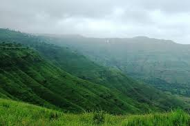
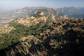
A rocky terrain marked by boulders, its elevation ranges between 100 and 1,000 metres, with an average of about 600 metres. It is sloping generally eastward. Thus, its principal rivers—the Godavari, Krishna, and Kaveri (Cauvery)-flow eastward from the Western Ghats to the Bay of Bengal. The plateau is drier than the coastal region of India and is arid in places.

It has been a region of conflict since early times. It produced some of the major dynasties in Indian history, including the Pallavas, Satavahana, Vakataka, Chalukya, and Rashtrakuta dynasties, also the Western Chalukya Empire, the Kadambas, the Yadava dynasty, the Kakatiya Empire, the Musunuri Nayakas regime, the Vijayanagara and the Maratha empires, as well as the Muslim Bahmani Sultanate, Deccan Sultanates, and the Nizam of Hyderabad. In attempting to conquer it in the 17th century, Aurangzeb fatally weakened the Moghul dynasty. In the late 18th century, the British defeated the French here.

Geographers have variously defined the Deccan region using indices such as rainfall, vegetation, soil type, or physical features. According to one geographical definition, it is the peninsular tableland lying to the south of the Tropic of Cancer. Its outer boundary is marked by the 300 m contour line, with Vindhya-Kaimur watersheds in the north. This area can be subdivided into two major geologic-physiographic regions: an igneous rock plateau with fertile black soil, and a gneiss peneplain with infertile red soil, interrupted by several hills.

Historians have defined the term Deccan differently. These definitions range from a narrow one by R. G. Bhandarkar (1920), who defines Deccan as the Marathi speaking area lying between the Godavari and Krishna rivers, to a broad one by K. M. Panikkar (1969), who defines it as the entire Indian peninsula to the south of the Vindhyas. Firishta (16th century) defined Deccan as the territory inhabited by the native speakers of Kannada, Marathi, and Telugu languages. Richard M. Eaton (2005) settles on this linguistic definition for a discussion of the region's geopolitical history.

The Deccan era Plateau is a large plateau in southern India that covers an area of 2,933,000 km². The plateau is surrounded by the Western Ghats to the west, the Eastern Ghats to the east and is bounded on the north by a line of hills (Malnad) running roughly from north-west to south-east.
Stewart N. Gordon (1998) notes that historically, the term "Deccan" and the northern border of Deccan has varied from Tapti River in the north to Godavari River in the south, depending on the southern boundary of the northern empires. Therefore, while discussing the history of the Marathas, Gordon uses Deccan as a "relational term", defining it as "the area beyond the southern border of a northern-based kingdom" of India.

The Deccan plateau is a topographically variegated region located south of the Gangetic plains -the portion lying between the Arabian Sea and the Bay of Bengal- and includes a substantial area to the north of the Satpura Range, which has popularly been regarded as the divide between northern India and the Deccan. The plateau is bounded on the east and west by the Ghats, while its northern extremity is the Vindhya Range. The Deccan's average elevation is about 600 metres , sloping generally eastward; its principal rivers, the Godavari, Krishna, and Kaveri, flow from the Western Ghats eastward to the Bay of Bengal. Tiruvannamalai in Tamil Nadu is often regarded as the Southern gateway of the Deccan plateau.
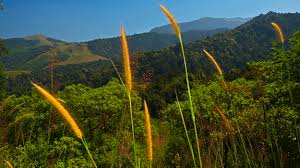
The Western Ghats mountain range is very massive and blocks the moisture from the southwest monsoon from reaching the Deccan Plateau, so the region receives very little rainfall. The eastern Deccan Plateau is at a lower elevation spanning the southeastern coast of India. Its forests are also relatively dry but serve to retain the rain to form streams that feed into rivers that flow into basins and then into the Bay of Bengal.

Most Deccan plateau rivers flow south. Most of the northern part of the plateau is drained by the Godavari River and its tributaries, including the Indravati River, starting from the Western Ghats and flowing east towards the Bay of Bengal. Most of the central plateau is drained by the Tungabhadra River, Krishna River and its tributaries, including the Bhima River, which also run east. The southernmost part of the plateau is drained by the Kaveri River, which rises in the Western Ghats of Karnataka and bends south to break through the Nilgiri Hills at the island town of Shivanasamudra and then falls into Tamil Nadu at Hogenakal Falls before flowing into the Stanley Reservoir and the Mettur Dam that created the reservoir, and finally emptying into the Bay of Bengal.

On the western edge of the plateau lie the Sahyadri, the Nilgiri, the Anaimalai and the Elamalai Hills, commonly known as Western Ghats. The average height of the Western Ghats, which run along the Arabian Sea, goes on increasing towards the south. Anaimudi Peak in Kerala, with a height of 2,695 m above sea level, is the highest peak of peninsular India. In the Nilgiris lie Ootacamund, the well-known hill station of southern India. The western coastal plain is uneven and swift rivers flow through it that form beautiful lagoons and backwaters, examples of which can be found in the state of Kerala. The east coast is wide with deltas formed by the rivers Godavari, Mahanadi and Kaveri. Flanking the Indian peninsula on the western side are the Lakshadweep Islands in the Arabian Sea and on the eastern side lie the Andaman and Nicobar islands in the Bay of Bengal.
The eastern Deccan plateau, called Telangana and Rayalaseema, is made of vast sheets of massive granite rock, which effectively traps rainwater. Under the thin surface layer of soil is the impervious gray granite bedrock. It rains here only during some months.Comprising the northeastern part of the Deccan Plateau, the Telangana Plateau has an area of about 148,000 km2, a north–south length of about 770 km, and an east–west width of about 515 km. The plateau is drained by the Godavari River taking a southeasterly course; by the Krishna River, which divides the peneplain into two regions; and by the Pennai Aaru River flowing in a northerly direction. The plateau's forests are moist deciduous, dry deciduous, and tropical thorn.

Most of the population of the region is engaged in agriculture; cereals, oilseeds, cotton, and pulses (legumes) are the major crops. There are multipurpose irrigation and hydroelectric-power projects, including the Pochampad, Bhaira Vanitippa, and Upper Pennai Aaru. Industries (located in Hyderabad, Warangal, and Kurnool) produce cotton textiles, sugar, foodstuffs, tobacco, paper, machine tools, and pharmaceuticals. Cottage industries are forest-based (timber, firewood, charcoal, bamboo products) and mineral-based (asbestos, coal, chromite, iron ore, mica, and kyanite). Having once constituted a segment of the ancient continent of Gondwanaland, this land is the oldest and most stable in India. The Deccan plateau consists of dry tropical forests that experience only seasonal rainfall.

The large cities in the Deccan are Bangalore, the capital of Karnataka; Hyderabad, the capital of Telangana; Pune, the cultural hub of Maharashtra; Nagpur, the second capital of Maharashtra and Nashik, the wine capital of Maharashtra. Other major cities include Hubli, Mysore, Gulbarga and Bellary in Karnataka; Aurangabad, Solapur, Amravati, Kolhapur, Akola, Latur, Sangli, Jalgaon, Nanded, Dhule, Chandrapur and Satara in Maharashtra; Hosur, Krishnagiri, Tiruvannamalai, Vellore and Ambur in Tamil Nadu; Amaravati, Visakhapatnam, Kurnool,Vijayawada, Guntur, Anantapur, Rajahmundry, Eluru, in Andhra Pradesh; and Warangal, Karimnagar, Ramagundam, Nizamabad, Suryapet, Siddipet, Nalgonda, Mahbubnagar in present-day Telangana and Jagdalpur, Bhawanipatna in the Northeastern part of the Deccan Plateau.
No comments:
Post a Comment