Showing posts with label PLATEAU. Show all posts

Sunday, December 4, 2022

Plateau

In geology and physical geography, a plateau, also called a high plain or a tableland, is an area of a highland consisting of flat terrain that is raised sharply above the surrounding area on at least one side. Often one or more sides have deep hills or escarpments. Plateaus can be formed by a number of processes, including upwelling of volcanic magma, extrusion of lava, and erosion by water and glaciers. Plateaus are classified according to their surrounding environment as intermontane, piedmont, or continental. A few plateaus may have a small flat top while others have wide ones.

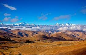
Tibetan Plateau


The Tibetan Plateau, also known as the Qinghai-Tibet Plateau or the Qing-Zang Plateau or as the Himalayan Plateau in India, is a vast elevated plateau located at the intersection of South, Central and East Asia covering most of the Tibet Autonomous Region,most of Qinghai, western half of Sichuan, Southern Gansu provinces in Western China, southern Xinjiang, Bhutan, the Indian regions of Ladakh and Lahaul and Spiti (Himachal Pradesh) as well as Gilgit-Baltistan in Pakistan, northwestern Nepal, eastern Tajikistan and southern Kyrgyzstan.

Pajarito Plateau


The Pajarito Plateau is a volcanic plateau in north central New Mexico, United States. The plateau, part of the Jemez Mountains, is bounded on the west by the Sierra de los Valles, the range forming the east rim of the Valles Caldera, and on the east by the Puye escarpment, which rises about 90 to 100 m above the Rio Grande valley about 1.6 km west of the river. 

Columbia Plateau

The Columbia Plateau is a geologic and geographic region that lies across parts of the U.S. states of Washington, Oregon, and Idaho. It is a wide flood basalt plateau between the Cascade Range and the Rocky Mountains, cut through by the Columbia River.

Deccan Plateau


The Deccan Plateau is defined as the entire southern peninsula of India south of the Narmada River. It is a high triangular tableland, bounded on the west and east by the Western Ghats and the Eastern Ghats, respectively, that meet at the plateau’s southern tip and to the north, by the Satpura and Vindhya Ranges.

Colorado Plateau


The Colorado Plateau, also known as the Colorado Plateau Province is a physiographic and desert region of the Intermontane Plateaus, roughly centered on the Four Corners region of the southwestern United States. This province covers an area of 336,700 km2 within western Colorado, northwestern New Mexico, southern and eastern Utah, northern Arizona, and a tiny fraction in the extreme southeast of Nevada. About 90% of the area is drained by the Colorado River and its main tributaries: the Green, San Juan, and Little Colorado. Most of the remainder of the plateau is drained by the Rio Grande and its tributaries.

Giza Plateau


The Giza Plateau is a plateau in Giza, on the outskirts of Cairo, Egypt, site of the Fourth Dynasty Giza Necropolis, which includes the Great Pyramids of Khufu, Khafre and Menkaure, the Great Sphinx, several cemeteries, a workers' village and an industrial complex. The plateau is elevated approximately 60 meters above sea-level.