
The Colorado Plateau, also known as the Colorado Plateau Province is a physiographic and desert region of the Intermontane Plateaus, roughly centered on the Four Corners region of the southwestern United States. This province covers an area of 336,700 km2 within western Colorado, northwestern New Mexico, southern and eastern Utah, northern Arizona, and a tiny fraction in the extreme southeast of Nevada. About 90% of the area is drained by the Colorado River and its main tributaries: the Green, San Juan, and Little Colorado. Most of the remainder of the plateau is drained by the Rio Grande and its tributaries.
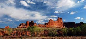
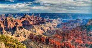
The Colorado Plateau is largely made up of high desert, with scattered areas of forests. In the southwest corner of the Colorado Plateau lies the Grand Canyon of the Colorado River. Much of the Plateau's landscape is related to the Grand Canyon in both appearance and geologic history. The nickname "Red Rock Country" suggests the brightly colored rock left bare to the view by dryness and erosion. Domes, hoodoos, fins, reefs, river narrows, natural bridges, and slot canyons are only some of the additional features typical of the Plateau.

The Colorado Plateau has the greatest concentration of U.S. National Park Service (NPS) units in the country outside the Washington, DC metropolitan area. Among its eight national parks are Grand Canyon, Zion, Bryce Canyon, Capitol Reef, Canyonlands, Arches, Mesa Verde, and Petrified Forest. Among its 18 national monuments and other protected areas managed by the NPS, the United States Forest Service, and the Bureau of Land Management are Bears Ears, Rainbow Bridge, Dinosaur, Hovenweep, Wupatki, Sunset Crater Volcano, Grand Staircase-Escalante, El Malpais, Natural Bridges, Canyons of the Ancients, Chaco Culture National Historical Park and the Colorado National Monument.
This province is bounded by the Rocky Mountains in Colorado and by the Uinta Mountains and Wasatch Mountains branches of the Rockies in northern and central Utah. It is also bounded by the Rio Grande rift, Mogollon Rim, and the Basin and Range Province. Isolated ranges of the Southern Rocky Mountains, such as the San Juan Mountains in Colorado and the La Sal Mountains in Utah, intermix into the central and southern parts of the Colorado Plateau.

As the name implies, the High Plateaus Section is, on average, the highest section. North-south trending normal faults that include the Hurricane, Sevier, Grand Wash, and Paunsaugunt separate the section's component plateaus. This fault pattern is caused by the tensional forces pulling apart the adjacent Basin and Range Province to the west, making this section transitional. Occupying the southeast corner of the Colorado Plateau is the Datil Section. Thick sequences of mid-Tertiary to late-Cenozoic-aged lava covers this section. The development of the province has, in large part, been influenced by structural features in its oldest rocks. Part of the Wasatch Line and its various faults form the province's western edge. Faults that run parallel to the Wasatch Fault that lies along the Wasatch Range form the boundaries between the plateaus in the High Plateaus Section. The Uinta Basin, Uncompahgre Uplift, and the Paradox Basin were also created by movement along structural weaknesses in the region's oldest rock.
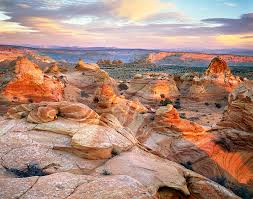
Some sources also include the Tushar Mountain Plateau as part of the Colorado Plateau, but others do not. The mostly flat-lying sedimentary rock units that make up these plateaus are found in component plateaus that are between 1,500 to 3,350 m above sea level. A supersequence of these rocks is exposed in the various cliffs and canyons (including the Grand Canyon) that make up the Grand Staircase. Increasingly younger east-west trending escarpments of the Grand Staircase extend north of the Grand Canyon and are named for their color.
Within these rocks are abundant mineral resources, including uranium, coal, petroleum, and natural gas. A study of the area's unusually clear geologic history (laid bare due to the arid and semiarid conditions) has greatly advanced that science. A rain shadow from the Sierra Nevada far to the west and the many ranges of the Basin and Range means that the Colorado Plateau receives 15 to 40 cm of annual precipitation. Higher areas receive more precipitation and are covered in forests of pine, fir, and spruce. Though it can be said that the Plateau roughly centers on the Four Corners, Black Mesa in northern Arizona is much closer to the east-west, north-south midpoint of the Plateau Province. Lying southeast of Glen Canyon and southwest of Monument Valley at the north end of the Hopi Reservation, this remote coal-laden highland has about half of the Colorado Plateau's acreage north of it, half south of it, half west of it, and half east of it.
No comments:
Post a Comment