Erosional landforms include headlands, bays, caves, arches, stacks, stumps and wave-cut platforms. There are also depositional landforms such as beaches, spits and bars. The process of erosion can create different landforms along the coastline.
Headlands and bays
Cliffs along the coastline do not erode at the same pace. When a stretch of coastline is formed from different types of rock, headlands and bays can form. Bands of soft rock such as clay and sand are weaker therefore they can be eroded quickly. This process forms bays. A bay is an inlet of the sea where the land curves inwards, usually with a beach. Hard rock such as chalk is more resistant to the processes of erosion.
When the softer rock is eroded inwards, the hard rock sticks out into the sea, forming a headland. Erosional features such as wave-cut platforms and cliffs can be found on headlands, since they are more open to the waves. Bays are more sheltered with constructive waves which deposit sediment to form a beach.
Cliffs and wave-cut platforms
Cliffs are shaped through erosion and weathering. Soft rock erodes quickly and forms gentle sloping cliffs, whereas hard rock is more resistant and forms steep cliffs. A wave-cut platform is a wide gently-sloping surface found at the foot of a cliff.
A wave-cut platform is formed when the following occurs:
The sea attacks the base of the cliff between the high and low water mark.
A wave-cut notch is formed by erosional processes such as abrasion and hydraulic action - this is a dent in the cliff usually at the level of high tide.
As the notch increases in size, the cliff becomes unstable and collapses, leading to the retreat of the cliff face.
The backwash carries away the eroded material, leaving a wave-cut platform.
The process repeats. The cliff continues to retreat.
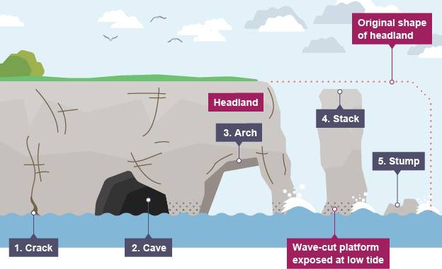
Caves, arches, stacks and stumps
Caves, arches, stacks and stumps are erosional features that are commonly found on a headland.
Cracks are widened in the headland through the erosional processes of hydraulic action and abrasion.
As the waves continue to grind away at the crack, it begins to open up to form a cave.
The cave becomes larger and eventually breaks through the headland to form an arch.
The base of the arch continually becomes wider through further erosion, until its roof becomes too heavy and collapses into the sea. This leaves a stack (an isolated column of rock).
The stack is undercut at the base until it collapses to form a stump.
When water loses its energy, any sediment it is carrying is deposited. The build-up of deposited sediment can form different features along the coast.
Beaches
Beaches are made up from eroded material that has been transported from elsewhere and then deposited by the sea. For this to occur, waves must have limited energy, so beaches often form in sheltered areas like bays.
Constructive waves build up beaches as they have a strong swash and a weak backwash. Sandy beaches are usually found in bays where the water is shallow and the waves have less energy.
Pebble beaches often form where cliffs are being eroded, and where there are higher energy waves. A cross-profile of a beach is called the beach profile. The beach profile has lots of ridges called berms. They show the lines of the high tide and the storm tides. A sandy beach typically has a gentle sloping profile, whereas a shingle beach can be much steeper.
The size of the material is larger at the top of the beach, due to the high-energy storm waves carrying large sediment. The smallest material is found nearest the water as the waves break here and break down the rock through attrition.
Spits
A spit is an extended stretch of sand or shingle jutting out into the sea from the land. Spits occur when there is a change in the shape of the landscape or there is a river mouth. A spit or sandspit is a deposition bar or beach landform off coasts or lake shores. It develops in places where re-entrance occurs, such as at a cove's headlands, by the process of longshore drift by longshore currents.
The drift occurs due to waves meeting the beach at an oblique angle, moving sediment down the beach in a zigzag pattern. This is complemented by longshore currents, which further transport sediment through the water alongside the beach. These currents are caused by the same waves that cause the drift.
This is how spits are formed :
Sediment is carried by longshore drift.
When there is a change in the shape of the coastline, deposition occurs. A long thin ridge of material is deposited. This is the spit.
A hooked end can form if there is a change in wind direction.
Waves cannot get past a spit, therefore the water behind a spit is very sheltered. Silts are deposited here to form salt marshes or mud flats.
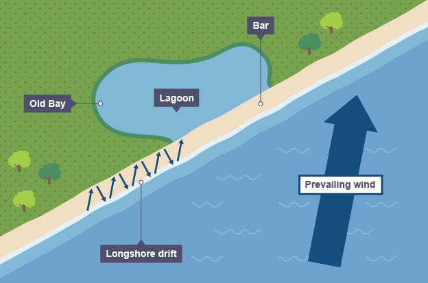
Bars
Sometimes a spit can grow across a bay, and joins two headlands together. This landform is known as a bar. They can trap shallow lakes behind the bar, these are known as lagoons. Lagoons do not last forever and may be filled up with sediment.
A bay bar is very similar to a spit. It is a ridge of sand or single that joins two headlands on either side of a bay. It is formed due to longshore drift transporting sediment along the coastline. Behind the bar, a lagoon is created, where water has been trapped and the lagoon may gradually be infilled as a salt marsh develops due to it being a low energy zone, which encourages deposition.
Offshore bar
An offshore bar is a raised area of seabed that is found offshore. They usually form adjacent to the coastline. They are formed in areas with high levels of sediment on a beach and where the sea is shallow. They form when sediment is transported on and off a beach. Destructive waves remove sediment from the beach and form the offshore bar. Constructive waves transport material from the offshore bar back onto the beach.
Visible offshore bars, found in parallel to the coast are known as barrier islands. Barrier islands are visible offshore bars that form parallel to the coast, often in chains. At high tide, the submerged offshore bar can be identified by a line of breakers revealing its position as waves break on it due to increased friction.
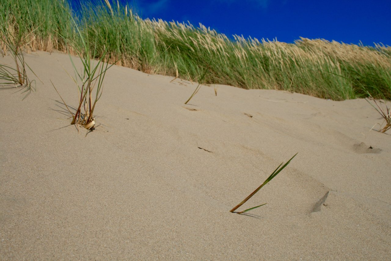
Sand dunes
Sand dunes are small ridges or hills of sand found at the top of a beach, above the reach of the waves. Onshore winds (winds blowing inland from the sea) cause the formation of sand dunes at the back of a beach. Sand is deposited by the wind around an object such as a rock, forming embryo dunes. Over time, vegetation such as marram grass stabilise the sand dunes forming foredunes. As the vegetation around the foredunes decomposes nutrients are released and soil begins to form. A wider range of plants are then able to colonise the dunes.
Dorset coastline
Dorset is located in the south of England. Its coastline has examples of many erosional and depositional landforms. For example :
Swanage is an example of a headland and bay
Old Harry Rocks is an example of caves, stacks and stumps
at Chesil Beach there is a bar
Swanage Bay
The area around Swanage is made up of bands of hard and soft rock. The soft rock is made of clay and sands, and the hard rock is chalk and limestone. As erosion processes take place, the clay erodes away quicker than the limestone and chalk. This forms headlands and bays, creating Swanage Bay and two headlands - Ballard Point and Durlston Head.
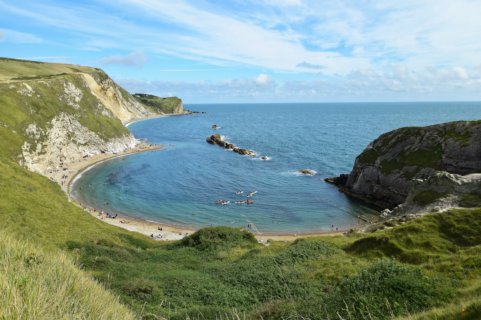
Old Harry Rocks
Old Harry Rocks are located on the headland between Swanage and Studland Bay. The headland is made out of chalk, a hard rock. The headland juts out into the sea, so it is more vulnerable to high-energy waves. This caused the formation of Old Harry, a stack. Over time Old Harry will collapse to form a stump.
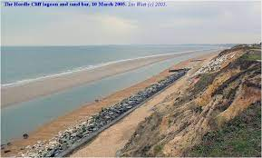
Chesil Beach
Chesil Beach is an example of a bar. Sediment has been deposited over time to form a spit. The spit has continued to join to the Isle of Portland. Behind the spit there is The Fleet, a lagoon.


No comments:
Post a Comment