
There are two major types of coastal morphology: one is dominated by erosion and the other by deposition. They exhibit distinctly different landforms, though each type may contain some features of the other. In general, erosional coasts are those with little or no sediment, whereas depositional coasts are characterized by abundant sediment accumulation over the long term. Both temporal and geographic variations may occur in each of these coastal types.

Erosional coasts typically exhibit high relief and rugged topography. They tend to occur on the leading edge of lithospheric plates, the west coasts of both North and South America being excellent examples. Glacial activity also may give rise to erosional coasts, as in northern New England and in the Scandinavian countries. Typically, these coasts are dominated by exposed bedrock with steep slopes and high elevations adjacent to the shore. Although these coasts are erosional, the rate of shoreline retreat is slow due to the resistance of bedrock to erosion. The type of rock and its lithification are important factors in the rate of erosion.
Sea cliffs
The most widespread landforms of erosional coasts are sea cliffs. These very steep to vertical bedrock cliffs range from only a few metres high to hundreds of metres above sea level. Their vertical nature is the result of wave-induced erosion near sea level and the subsequent collapse of rocks at higher elevation. Cliffs that extend to the shoreline commonly have a notch cut into them where waves have battered the bedrock surface.

At many coastal locations there is a thin, narrow veneer of sediment forming a beach along the base of sea cliffs. This sediment may consist of sand, but it is more commonly composed of coarse material-cobbles or boulders. Beaches of this kind usually accumulate during relatively low wave-energy conditions and are removed during the stormy season when waves are larger. The coasts of California and Oregon contain many places where this situation prevails. The presence of even a narrow beach along a rocky coast provides the cliffs protection against direct wave attack and slows the rate of erosion.

Wave-cut platforms
At the base of most cliffs along a rocky coast one finds a flat surface at about the mid-tide elevation. This is a benchlike feature called a wave-cut platform, or wave-cut bench. Such surfaces may measure from a few metres to hundreds of metres wide and extend to the base of the adjacent cliff. They are formed by wave action on the bedrock along the coast. The formation process can take a long time, depending on the type of rock present. The existence of extensive wave-cut platforms thus implies that sea level did not fluctuate during the periods of formation. Multiple platforms of this type along a given reach of coast indicate various positions of sea level.

Sea stacks
Erosion along rocky coasts occurs at various rates and is dependent both on the rock type and on the wave energy at a particular site. As a result of the above-mentioned conditions, wave-cut platforms may be incomplete, with erosional remnants on the horizontal wave-cut surface. These remnants are called sea stacks, and they provide a spectacular type of coastal landform. Some are many metres high and form isolated pinnacles on the otherwise smooth wave-cut surface. Because erosion is a continual process, these features are not permanent and will eventually be eroded, leaving no trace of their existence.

Sea arches
Another spectacular type of erosional landform is the sea arch, which forms as the result of different rates of erosion typically due to the varied resistance of bedrock. These archways may have an arcuate or rectangular shape, with the opening extending below water level. The height of an arch can be up to tens of metres above sea level.

It is common for sea arches to form when a rocky coast undergoes erosion and a wave-cut platform develops. Continued erosion can result in the collapse of an arch, leaving an isolated sea stack on the platform. Still further erosion removes the stack, and eventually only the wave-cut platform remains adjacent to the eroding coastal cliff.

Landforms of depositional coasts
Coasts adjacent to the trailing edge of lithospheric plates tend to have widespread coastal plains and low relief. The Atlantic and Gulf coasts of the United States are representative. Such coasts may have numerous estuaries and lagoons with barrier islands or may develop river deltas. They are characterized by an accumulation of a wide range of sediment types and by many varied coastal environments. The sediment is dominated by mud and sand; however, some gravel may be present, especially in the form of shell material.

Depositional coasts may experience erosion at certain times and places due to such factors as storms, depletion of sediment supply, and rising sea level. The latter is a continuing problem as the mean annual temperature of the Earth rises and the ice caps melt. Nevertheless, the overall, long-range tendency along these coasts is that of sediment deposition.

All of the processes discussed at the beginning of this section are in evidence along depositional coasts. Waves, wave-generated currents, and tides significantly influence the development of depositional landforms. In general, waves exert energy that is distributed along the coast essentially parallel to it. This is accomplished by the waves themselves as they strike the shore and also by the longshore currents that move along it. In contrast, tides tend to exert their influence perpendicular to the coast as they flood and ebb. The result is that the landforms that develop along some coasts are due primarily to wave processes while along other coasts they may be due mainly to tidal processes. Some coasts are the result of near equal balance between tide and wave processes. As a consequence, investigators speak of wave-dominated coasts, tide-dominated coasts, and mixed coasts.

A wave-dominated coast is one that is characterized by well-developed sand beaches typically formed on long barrier islands with a few widely spaced tidal inlets. The barrier islands tend to be narrow and rather low in elevation. Longshore transport is extensive, and the inlets are often small and unstable. Jetties are commonly placed along the inlet mouths to stabilize them and keep them open for navigation. The Texas and North Carolina coasts of the United States are excellent examples of this coastal type.

Tide-dominated coasts are not as widespread as those dominated by waves. They tend to develop where tidal range is high or where wave energy is low. The result is a coastal morphology that is dominated by funnel-shaped embayments and long sediment bodies oriented essentially perpendicular to the overall coastal trend. Tidal flats, salt marshes, and tidal creeks are extensive. The West German coast of the North Sea is a good example of such a coast.

Mixed coasts are those where both tidal and wave processes exert considerable influence. These coasts characteristically have short stubby barrier islands and numerous tidal inlets. The barriers commonly are wide at one end and narrow at the other. Inlets are fairly stable and have large sediment bodies on both their landward and seaward sides. The Georgia and South Carolina coasts of the United States typify a mixed coast.

General coastal morphology
Depositional coasts can be described in terms of three primary large-scale types: (1) deltas, (2) barrier island/estuarine systems, and (3) strand-plain coasts. The latter two have numerous features in common.

Deltas
An accumulation of sediment at the mouth of a river extending beyond the trend of the adjacent coast is called a delta. Deltas vary greatly in both size and shape, but they all require that more sediment is deposited at the river mouth than can be carried away by coastal processes. A delta also requires a shallow site for accumulation-namely, a gently sloping continental shelf.

The size of a delta is typically related to the size of the river, specifically to its discharge. The shape of a delta, on the other hand, is a result of the interaction of the river with tidal and wave processes along the coast. A classification utilizing each of these three factors as end members provides a good way of considering the variation in delta morphology (Figure 1). River-dominated deltas are those where both wave and tidal current energy on the coast is low and the discharge of water and sediment are little affected by them. The result is an irregularly shaped delta with numerous digitate distributaries.The Mississippi Delta is a good example of a river-dominated delta.

Waves may remove much of the fine deltaic sediment and smooth the outer margin of the delta landform as well. This results in a smooth, cuspate delta that has few distributaries. The São Francisco Delta in Brazil is such a delta. Some wave-dominated deltas are strongly affected by longshore currents, and the river mouth is diverted markedly along the coast. The Sénégal Delta on the west coast of Africa is an example.

Tide-dominated deltas tend to be developed in wide, funnel-shaped configurations with long sand bodies that fan out from the coast. These sand bodies are oriented with the strong tidal currents of the delta. Tidal flats and salt marshes also are common. The Ord Delta in northern Australia and the Ganges-Brahmaputra Delta in Bangladesh are representative of such a deltaic type.

Barrier island/estuarine systems
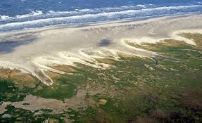
Many depositional coasts display a complex of environments and landforms that typically occur together. Irregular coasts have numerous embayments, many of which are fed by streams. Such embayments are called estuaries, and they receive much sediment due to runoff from an adjacent coastal plain. Seaward of the estuaries are elongate barrier islands that generally parallel the shore. Consisting mostly of sand, they are formed primarily by waves and longshore currents. These barrier islands are typically separated from the mainland and may have lagoons, which are long, narrow, coastal bodies of water situated between the barrier and the mainland.
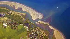
Most barrier islands contain a well-developed beach, coastal dunes, and various environments on their landward side, including tidal flats, marshes, or washover fans. Such coastal barriers are typically interrupted by tidal inlets, which provide circulation between the various coastal bays and the open marine environment. These inlets also are important pathways for organisms that migrate between coastal and open marine areas as well as for pleasure and commercial boat traffic.

Strand-plain coasts
Some wave-dominated coasts do not contain estuaries and have no barrier island system. These coasts, however, do have beaches and dunes, and may even have coastal marshes. The term strand plain has been applied to coasts of this sort. Examples include parts of western Louisiana and eastern Texas. In most respects, they are similar in morphology to barrier islands but lack inlets.

Beaches and coastal dunes
There are several specific landforms representative of coastal environments that are common to each of the three major categories described above. Especially prominent among these are beaches and dunes. They are the primary landforms on barrier islands, strand-plain coasts, and many deltas, particularly the wave-dominated variety.

Beaches
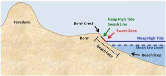
A consideration of the beach must also include the seaward adjacent nearshore environment because the two are intimately related. The nearshore environment extends from the outer limit of the longshore bars that are usually present to the low-tide line. In areas where longshore bars are absent, it can be regarded as coincident with the surf zone. The beach extends from the low-tide line to the distinct change in slope and/or material landward of the unvegetated and active zone of sediment accumulation. It may consist of sand, gravel, or even mud, though sand is the most common beach material.

The beach profile typically can be divided into two distinct parts: (1) the seaward and relatively steep sloping foreshore, which is essentially the intertidal beach, and (2) the landward, nearly horizontal backshore. Beach profiles take on two different appearances, depending on conditions at any given time. During quiescent wave conditions, the beach is said to be accretional, and both the foreshore and backshore are present. During storm conditions, however, the beach experiences erosion, and the result is typically a profile that shows only the seaward sloping foreshore. Because the beach tends to repair itself during nonstorm periods, a cyclic pattern of profile shapes is common.

The nearshore zone is where waves steepen and break, and then re-form in their passage to the beach, where they break for the last time and surge up the foreshore. Much sediment is transported in this zone, both along the shore and perpendicular to it. During storms the waves tend to be steep, and erosion of the beach occurs with sediment transported offshore. The intervening calmer conditions permit sediment to be transported landward and rebuild the beach. Because wave conditions may change daily, the nature of the profile and the sediment on the foreshore portion of the beach may also change daily. This is the zone of continual change on the beach.

The backshore of the beach is not subjected to wave activity except during storm conditions. It is actually in the supra-tidal zone-i.e., the zone above high tide where inundation by water is caused not by regular astronomical tides but rather by storm-generated tides. During nonstorm conditions the back-beach is relatively inactive except for wind action, which may move sediment. In most cases, there is an onshore component to the wind, and sediment is carried from the back-beach landward, typically forming dunes. Any obstruction on the back-beach, such as vegetation, pieces of driftwood, fences, or even trash discarded by people, results in wind-blown sand accumulation.

There are variations in beach forms along the shore as well as in those perpendicular to the shore. Most common is the rhythmic topography that is seen along the foreshore. A close look at the shoreline along most beaches will show that it is not straight or gently curved but rather that it displays a regularly undulating surface much like a low-amplitude sine curve. This is seen both on the plan view of the shoreline and the topography of the foreshore. The spacing is regular along a given reach of coast, but it may vary from place to place or from time to time at a given place. At some locations, concentrations of gravel or shells may develop, forming beach cusps (more or less triangular deposits that point seaward) during some wave conditions.
Although there is a common trend to the beach profile, some variation exists both because of energy conditions and because of the material making up the beach. Generally speaking, a beach that is accumulating sediment and experiencing low-energy conditions tends to have a steep foreshore, whereas the same beach would have a relatively gentle foreshore during storm conditions when erosion is prevalent. The grain size of beach sediment also is an important factor in the slope of the foreshore. In general, the coarser the constituent grains, the steeper the foreshore. Examples include the gravel beaches of New England, as contrasted to the gently sloping sand beaches of the Texas coast.

Coastal dunes
Immediately landward of the beach are commonly found large, linear accumulations of sand known as dunes. (For coverage of dunes in arid and semiarid regions, see sand dune.) They form as the wind carries sediment from the beach in a landward direction and deposits it wherever an obstruction hinders further transport. Sediment supply is the key limiting factor in dune development and is the primary reason why some coastal dunes, such as those on the west Florida peninsula, are quite small, whereas others in such areas as the Texas coast and the Florida panhandle have large dunes.
Small wind-shadow dunes, or coppice mounds, actually may form on the backshore of the beach. If sediment continues to be supplied and beach erosion does not destroy them, these small sand accumulations will become foredunes, the seaward-most line of coastal dunes. It is in this fashion that a coast progrades, or grows seaward. Many barrier-island or strand-plain coasts exhibit numerous, essentially parallel dune ridges testifying to this type of growth.
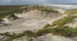
The sediment in dunes tends to be fine to medium sand that is quite well sorted. Shell debris or other material is uncommon unless it is the same size or mass as the dune sand. There are various types of vegetation that grow on the dune surface and stabilize it. These grasses and vines often can be seen on the backshore portion of beaches as well. Dunes lacking vegetation are usually active and exhibit various signs of sand mobility. Most widespread are the nearly ubiquitous ripples that cover the dune surface. Large lobes of sand or even an entire dune may also move as wind blows across the dune. This activity results in cross stratification of the dune in large sweeping patterns of wedge-shaped packages of sand.

No comments:
Post a Comment