Sunday, June 4, 2023

Da Dia Cliff - Phu Yen

Formed from basalt columns, these natural rock columns are made up of solidified lava flows, caused by the contraction of volcanic rock as it cools. Columns often have a hexagonal, pentagonal or octagonal cross-section due to rapid cooling. When the lava flows into the sea, it will cool down suddenly and will create basalt columns with a spectacular structure...Is one of the products of the lava flow when it cools down suddenly, similar to the famous Giant's Causeway landmark in Northern Ireland, although the area of ​​Da Dia Cliff is smaller, it has many similar features as in the above place.

Photos Clip 9-10-2018 by Doan NT

Ghenh Da Dia or Ganh Da Dia literally means the sea cliff of stone plates. It is a seashore area of uniformly interlocking basalt rock columns located along the coast in An Ninh Dong Commune, Phu Yen Province, Vietnam. The area is about 100 meters wide and 250 meters long, composed of an estimated 35,000 columns of basalt rocks. 

Watching the Cliff of Stone Plates with slate color lying silently next to the rushing sea waves, visitors will find themselves getting lost in a giant Lego construction that nature has given Tuy An. Millions of years ago, this place was a giant volcanic belt which constantly erupted. When the lava flowed from the volcanic area to the sea, it was suddenly frozen by the cold water of the sea and formed the burning stone pillars with hexagonal and circular shapes. 


These burning stone pillars then became the stone pillars with slate color. They were overlap and formed the Cliff of Stone Plates like what visitors can see now. The Cliff of Stone Plates has a beautiful curve shape that has become the inspiration for many professional photographers.

The rocks are dark lava columns with roughly flat surfaces of different shapes such as round, pentagon, hexagon, polygon etc. Ghenh Da Dia looks like a gigantic beehive or a pile of dinner plates, hence they have the name. These rock columns were created from volcanic eruptions millions of years ago. When the molten basalt flows met cold water, they solidified and shaped these rare polygonal formation due to thermal contraction effects. 


I. Related regions

Ba River - Geoheritage

The Ba River fault zone has a special position in the geological structure of the South Central region. This is a large fault zone in the form of a trench, which also contains a lot of important information about the history of geological development, geological heritage as well as the development history of the natural and human world in the area. The Ba river develops along this fault zone, with basins in the provinces of Kon Tum, Gia Lai, Dak Lak and Phu Yen. This is the only large river in the Central Highlands that empties into the East Sea through the Da Rang estuary (in Tuy Hoa city, Phu Yen province). The Ba River basin is rich in natural resources, playing a special role in the socio-economic development of the Central Highlands and related central coastal provinces.


The heritages of outstanding value for tourism are: Geoheritage of type A - Paleolithic: there are wood fossils (silicification) of great scientific, aesthetic and economic value in Chu A Thai (Phu Thien district). Gia Lai province) and some other places; there are very unique basalt tree mold fossils etc.; Geomorphological heritage type B - Geomorphology: there are waterfalls and waterfall landscape with spectacular and majestic beauty among the first class in the Central Highlands such as Waterfall 50, Kon Lok waterfall, Hang Doi waterfall, Phu Cuong waterfall, etc.; There are craters (yin, yang) and very beautiful crater landscapes such as Chu Dang Ya, Bien Ho, Ham Rong, Ia Bang, etc. contain high scientific, aesthetic and economic/tourism values; 


Geoheritage type C - Paleoenvironmental: there are silicified wood fossils in Neogen sediments, knee bridge basalt, tree molds in basalt, “Pele tears”, etc. characteristic for different geological formation conditions, scattered in Gia Lai. Geoheritage type D - Rocks: there are ancient metamorphic rocks (gneiss, striped slabs...), columnar basalt, spherical basalt, volcanic bombs, pink granite, etc. scattered in Kon Tum, Gia Lai, Dak Lak; Geological heritage type F - Mineral minerals: precious and semi-precious stones, gold, bauxite, etc. scattered in Kon Tum-Gia Lai-Dak Lak; Geological heritage type I - Tectonics (geological history): has the history of geological development of the Ba River fault zone, the topographic classification from Kon Tum to Phu Yen and the history of development of the Ba River basin, etc.; Geoheritage of type K - Cosmic issues: traces of tektite rains occurring in the ancient geological past are still preserved in Gia Lai, in which large tektites weighing up to 5-7kg have been collected. ...


Van Hoa Plateau

Ganh Da Dia is a set of adjacent prismatic stone pillars, one connecting the other adjacent to the water wave. There are vertical pillars, there are tilted pillars but still piled up like a stack of dishes, so it is called Ganh Da Dia. From a distance, Ganh Da Dia looks like a giant natural beehive. The basalt columns of Ganh Da Dia are believed by researchers to have formed millions of years ago, when molten lava flows spewing from volcanoes in the Van Hoa plateau (30 km away) met cold sea water. should freeze and crack.


Van Hoa Plateau is a plateau located on the Truong Son mountain range in the center of Phu Yen province, Vietnam. This plateau is located in 3 communes: Son Dinh, Son Long, Son Xuan in Son Hoa district and a part of Tuy An district, with an average altitude of about 400 m above sea level. The terrain gradually slopes from the west, northwest to southeast. The plateau is a potential rich basaltic red land formed by volcanic eruptions, pristine, with rich vegetation, lowland tropical forests covering 28% of the natural land. The forest has many precious wood species, many valuable flowers and animals.


Phu Yen is a land rich in potential in terms of geological heritage, cultural heritage, and biological diversity. The area of coastal districts and towns of Phu Yen province has full potential to build a geopark (Geopark) of Vietnam, towards a global Geopark. The proposed area for the establishment of a Geopark in Phu Yen covers an area of 6 districts, of which 4 are coastal districts of Ho Chi Minh City. Tuy Hoa, TX. Song Cau, TX. Dong Hoa, Tuy An district. The remaining 2 districts are Phu Hoa (including 4 communes and townships: Phu Hoa, Hoa An, Hoa Thang, Hoa Quang Bac), Son Hoa (including 3 communes: Son Xuan, Son Long, Son Dinh). The total natural area of the whole region is 152,700 ha.


Vuc Hom, Vuc Song waterfalls

About 10km from Van Hoa plateau, Vuc Hom and Vuc Song waterfalls are located in An Linh commune, with a total area of about 1ha. Both waterfalls have a water source pouring down from the cliff, revealing many tall basalt columns lined up close to each other, the stone columns have the same structure as Ganh Da Dia.


Vuc Song Waterfall is not high, only about 10 meters, but the steep waterfall wall consists of basalt pillars. Vuc Hom waterfall is higher than Vuc Song waterfall, with a water column height of about 20m. The space at the foot of Vuc Hom waterfall is also wider than the foot of Vuc Song waterfall, and is relatively flat to be able to set up tents and camp.


Kon Turn Massif

The Tuy Hòa area, locates at the eastern margin of the Kon Turn Massif, comprises a variety of sedimentary, volcanic and intrusive rocks formed from Paleozoic to Early Cenozoic. They are largely covered by unconsolidated Neogene I Quaternary sediments. The area has been strongly deformed by numerous tectonic events, the latest one has extended to the present. These tectonic movements include the presence of old and neotectonic fault systems, and terrane depression and elevation with numerous direct or indirect evidences. Intense tectonic activities have not only created various morphology differentiation controlled by basement structure but also various types of geological hazards including landslides and coastal erosion as well as local depression. 


The Kon Tum high grade polymetamorphic terrane is distributed in Mid of Trung Bộ. The core of this zone includes Paleoproterozoic-Mesoproterozoic Ngọc Linh - Kan Nắck block and the edge is composed of Hiệp Đức - Sa Thầy Early Caledonian orogenic belt and Ea Kar-Ea Drang Late Caledonian orogenic belt. In the Kon Tum high metamorphic terrane there develop strongly after Caledonian diverse and multistage petrotectonic assemblages. 


Ancient stone spring

An ancient stone spring discovered in Van village, Ia Ly town, Chu Pah district (Gia Lai) has attracted a lot of tourists to visit. In the opinion of geologists, these rocks are over 100 million years old. This rock stream is called Ia Ruai stone spring located in the territory of Ia Ly town and Ia Phi commune, Chu Pah district (Gia Lai). The stream flows through many Jrai villages before emptying into the reservoir of the Ia Ly Hydropower Plant. The section to Van village of Ia Ly town is about 1km long, rising to an ancient rock, with many exposed sections, concentrated and highest in two areas about 30 meters apart. 


The two sides of the stream are similar hexagonal stone bars, arranged close together into large, solid blocks like a solid block, similar to the rocks at Ganh Da Dia - a national monument. especially in Phu Yen province. The Department of Culture, Sports and Tourism of Gia Lai province will continue to survey to develop a plan for tourism development, supplement the inventory list and plan to compile a dossier of request for relic ranking for the site. this in the near future.


II. Similar structures around the world  Details

Basalt columns are natural pillars made of hardened lava, caused by the contraction of volcanic rock as it cools. The columns are often shaped like hexagons, pentagons, or octagons due to the "rapid"-i.e., over the course of a century-cooling process, and they can often form as vertical cliffs or terraced steps, sometimes descending directly into the ocean.

Giant's Causeway

Giant's Causeway is perhaps the world's most extraordinary and well-known example of basalt columns. Some 50 to 60 million years ago, a volcanic plateau of molten basalt formed on the north coast of Northern Ireland, and as it cooled, the hardening lava cracked into tidy hexagonal, columnar tiles that now border and descend into the sea. Now a UNESCO World Heritage site and national nature preserve (serving as a safe haven for marine life and seabirds), Giant's Causeway is visited by about a million people per year. Its name hails from ancient folklore: Before humans knew much about geology, it was believed that the geometric cracks were formed by the footsteps of giants.

Basaltic Prisms of Santa María Regla

The water rushing over the Basaltic Prisms of Santa María Regla make the ancient pillars look especially surreal. The columns are polygonal and vary in height from 100 to more than 150 feet tall. They contain a ravine whose water flows from the San Antonio Dam, often times causing a rainbow to form at the base of two waterfalls. The tourist attraction is located in Hildago, Mexico, and can be enjoyed via walkways and hanging bridges.

Devils Postpile National Monument

One of the most fantastic displays of basalt columns in the U.S. is that near Mammoth Mountain in California. Apart from Devils Postpile's regal appearance-a vertical, tree-topped cliff composed of long and symmetrical, interlocking pillars thought to be between 400 and 600 feet in thickness-the formation has had a whirlwind history. It was once included in Yosemite National Park, then removed due to the discovery of gold in the area, then almost demolished for the purpose of a hydroelectric dam, saved by the legendary John Muir, then-finally-protected as its own national monument. The formation of Devils Postpile is believed to be relatively recent, within the past 100,000 years.

Fingal's Cave

Scotland's Fingal's Cave and Northern Ireland's Giant's Causeway were caused by the same Paleocene-era volcanic event. However, the former offers a unique viewing experience. Here, on the uninhabited island of Staffa, the basalt columns line the walls of a sea cave like blocky stalactites made of hardened lava. The cave is 72 feet tall, 270 feet deep, and known particularly for its natural acoustics, which once inspired 19th century composer Felix Mendelssohn to write an overture in its name. Visitors can experience the bizarre echoing and explore the otherworldly scene by walking on footpaths along the columns.

Svartifoss 

Another basalt-column cliff decorated by falling water, Svartifoss in southern Iceland's Vatnajökull National Park is called "black waterfall" in Icelandic due to the dark color of the volcanic rock. The basalt formation, surrounded by Iceland's signature lush greenery, has inspired such architectural works as the National Theatre in Reykjavik and was featured in Bon Iver's music video for the song "Holocene." It can be reached via a short hiking track, but visitors are warned against swimming as some of the basalt has cracked off from the cliff and created quite a sharp surface under the water.

Takachiho Gorge

The basalt columns at Takachiho Gorge were formed some 270,000 years ago as a result of four eruptions of the Mount Aso volcano. Since, the Gokase River has cut through the columns, creating a narrow, V-shaped chasm through which beautiful blue-green water flows. Boats float down the four-mile gorge in the shadow of these 300-foot, red-tinted cliffs. The site has been protected as a National Scenic Spot and Natural Monument in Japan since 1934.

Cape Stolbchaty

Quite similar to Giant's Causeway are the cliffs at Cape Stolbchaty on Kunashir Island, between Russia and Japan. The rocks crack in the same hexagonal shape as the UK country's star attraction, and they create precipitous, 150-foot-tall seaside cliffs three times the height of Giant's Causeway. In places, the gray basalt columns descend diagonally like steps into the ocean and crop up offshore as rocky islands. The formations were created by an eruption of the nearby Mendeleev Volcano and are named after the Russian word for “columnar."
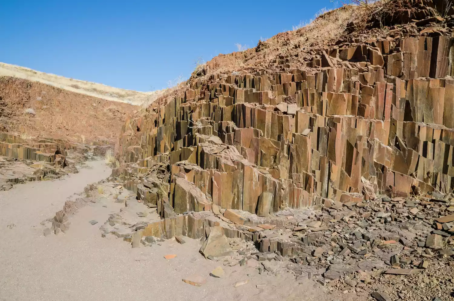
Organ Pipes

Named for the way they resemble the actual pipes of an organ, these Namibian rocks-some of them more than 15 feet tall-are about 150 million years old. They are located near another volcanic feature, Burnt Mountain, whose solidified lava flow is a popular subject for photographers. Both the formations have an extraordinary red tint that makes them appear fiery when the sun hits them right.

Cape Raoul

Originally dubbed Basaltic Cape by its founders, the towering columns and shrubby cliffs on the southeast coast of Tasmania, Australia, were renamed Raoul by French explorers in the early 19th century. The formations were caused by a Jurassic-era volcanic event (about 185 million years ago) that is believed to have covered a third of the island. Erosion from the wind and sea has created a sort of noncohesive, craggy aesthetic.

Hexagon Pool

Swimming in a pool surrounded by steep, 15-foot basalt cliffs is a once-in-a-lifetime experience to be had in Israel's Yehudiya Forest Nature Reserve. Most of the columns that contain the 65-by-100-foot Hexagon Pool-a scenic swimming hole formed by the Meshushim Stream rushing grandly over the formations-are greater than a foot in diameter. This is the most spectacular of many basalt formations within the reserve, all caused by activity in the Golan Heights volcanic field.


No comments: