
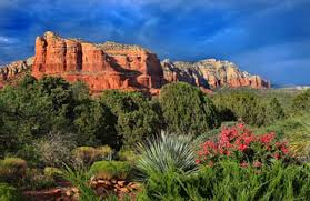
Courthouse Butte is a butte just north of the Village of Oak Creek, Arizona, south of Sedona in Yavapai County. Summit elevation is 1,662 m. It is just east of Bell Rock. Geologically, Courthouse Butte is composed of horizontally bedded sedimentary rock of the Permian Supai Formation.

Bell Rock and Courthouse Butte are two prominent sandstone peaks at the south edge of Sedona's red rock formations, at the center of what is probably the busiest hiking area in the region, since the rocks are easily accessed from the adjacent Highway 179, are viewed by several short, level trails, and are the first-reached scenic location for the majority of visitors, who arrive from I-17 to the south.

The rock is nearest the road, so sees by far the most people - either walking along the trail (Bell Rock Pathway) at the base, or climbing a little way up the slickrock slopes. The loop path round the larger Courthouse Butte to the east has more varied views and is less used, since it is quite long at 3.4 miles, or 4.1 miles if incorporating part of another path (Big Park Trail) to the south. The loop has good views of both buttes from all directions, and of higher cliffs to the north, while encountering varying terrain of rocky terraces, dry washes, light woodland and flower-filled grassland. Most of the trail lacks shade so the hike is testing in summer, despite having only small changes in gradient. All trails in the area are open to horses, and most to bikes as well, though one section of the Courthouse Butte loop, on the east side, crosses part of the Munds Mountain Wilderness, so cycles cannot make the full loop.

Trail
There are two access points to this wonderful trail :
From the south: (Bell Rock Pathway and Vista) take the wide Bell Rock Pathway from the kiosk toward Bell Rock. It climbs gently and at ½ mile there is a signed intersection with the Courthouse Butte Loop Trail. Continue ahead on the wide trail (this description is for taking the loop clockwise). The trail continues a gentle climb circling to the west of Bell Rock. It levels out and curves to the north below the slopes of Bell Rock.

From the north: (Courthouse Vista) walk southeast on the trail directly towards Bell Rock at ¼ mile the Trail intersects Bell Rock Pathway to you may then choose to circle Bell Rock and Courthouse Butte clockwise (turn east) or counterclockwise (turn west).

If circling clockwise, after turning east, follow the large cairns to the point where the wide Pathway turns north (left) and a sign shows the Courthouse Butte Loop Trail branching to the east. Go east. This narrower trail passes to the north of Courthouse Butte heading toward Lee Mountain. The next intersection is the Llama Trail, popular with mountain bikers, from the north. Continuing east, the trail passes to the right of a prominent dome-shaped outcrop, and then gradually descends, entering the Wilderness area.
It enters a dry wash, circles to the south over bare rock and climbs out onto level ground as it leaves the Wilderness area and continues to circle Courthouse Butte. Approaching Bell Rock, the trail meets the pathway once again. To return to the Bell Rock Vista and Pathway trailhead, go south, retracing the entry route for ½ mile to return to the kiosk. If returning to the Courthouse Vista Trailhead, continue clockwise around Bell Rock to the intersection of the parking area trail intersecting from the northwest. The loop is mostly un-shaded and can be hot in summer.
No comments:
Post a Comment