
Tamanrasset or Tamanghasset in Algeria. It was named after its province seat, Tamanrasset. The province has two national parks, more than any other in Algeria. They are Tassili n'Ajjer National Park and Ahaggar National Park. The province is the largest in Algeria as it is 557,906 km² large.
It is located in the deep southern region of Algeria and is 2000 km south of Algiers (capital of Algeria). On the north it is bordered by In Salah Province, on the north-east by Illizi Province, on the east by Djanet Province, on the south by In Guezzam Province, and on the west by Adrar Province, the second largest province by area, and Bordj Badji Mokhtar Province.

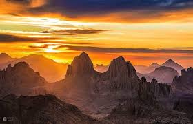
Tamanrasset also has an international border with Niger. The province is the largest Algerian province with area of 336,854 km2 although it is located in the heart of the desert. The Province of Tamanrasset has a moderate climate because of its mountainous terrain. The province has an elevation of 1,400 meters. The highest point of Tamanrasset Province is Mount Tahat, which is also the highest point of Algeria with 3,303 meters. The most well known tourist destination is the Tomb of Tinhan.

Tamanrasset, also called Tamanghasset and (after 1981) Tamenghest, formerly Fort Laperrine, town, southern Algeria. Located in the mountainous Ahaggar (Hoggar) region on the Wadi Tamanghasset, the town originated as a military outpost, guarding trans-Saharan trade routes. It has become an important way station on the north-south asphalt road called the Trans-Sahara Highway via northern Algeria, which reached Tamanrasset in 1980. Although the desert climate is mitigated by the town’s elevation of 1,378 metres, some of the world’s highest known shade temperatures exceeding 38 °C have been recorded there at the Jules Carde Observatory.

The town is a Tuareg Berber oasis settlement where citrus fruits, peaches, apricots, dates, almonds, figs, cereals, and corn (maize) are grown. Its red houses and magnificent rugged scenery make Tamanrasset a tourist attraction during the cooler months.

The surrounding region, located entirely within the Sahara, is a vast, extremely dry area. Its physiography includes the large sand dunes of the Grand Ergs Occidental and Oriental in the west and northeast and the Tademait Plateau (a sandstone and limestone escarpment ) in the north. The Ahaggar is an arid mountainous plateau (more than 900 metres above sea level) extending about 1,550 km north-south and 2,092 km east-west and culminating in Tahat, a peak 2,918 metres in elevation. Eroded sandstone plateaus (tassilis) extend from the Ahaggar. The sparse population of this region is partly settled and partly nomadic. The nomads principally inhabit the valleys of Atakor (the highest areas of the Ahaggar) and graze camels and goats where the scant rainfall is enough to support a steppelike growth of grasses.
In 1905 Charles Eugène de Foucauld, the French explorer and ascetic, built his hermitage in the town of Tamanrasset, where he compiled a Tuareg language grammar and dictionary. A memorial column was erected near the spot where he was assassinated in 1916. The Museum of the Hoggar specializes in Tuareg exhibits.
No comments:
Post a Comment