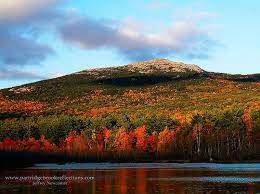

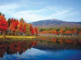
Mt. Monadnock has long been cited as one of the most frequently climbed mountains in the world. It bears a number of hiking trails, including the 180 km Metacomet-Monadnock Trail and the 80 km Monadnock-Sunapee Greenway. The summit is barren largely because of fires set by early settlers. The first major fire, set in 1800 to clear the lower slopes for pasture, swept through the stands of virgin red spruce on the summit and flanks of the mountain. Between 1810 and 1820, local farmers, who believed that wolves were denning in the blowdowns, set fire to the mountain again. The conflagration raged for weeks, destroying the topsoil and denuding the mountain above 610 m.

The term "monadnock" is used by American geologists to describe any isolated mountain formed from the exposure of a harder rock as a result of the erosion of a softer one once surrounding it (a landform termed "inselberg" ("island-peak") elsewhere in the world). The word "monadnock" is derived from an Abenaki word used to describe a mountain. Loosely translated, it means "mountain that stands alone", although the exact meaning of the word is uncertain. The term was adopted by early settlers of southern New Hampshire and later by American geologists as an alternative term for an inselberg or isolated mountain. Mount Monadnock is often called Grand Monadnock, to differentiate it from other Vermont and New Hampshire peaks with "Monadnock" in their names. Its official name on federal maps is "Monadnock Mountain".

Due to fires in the early 19th century which burned a majority of the top 90 m around the summit, there is little soil cover on the peak and surrounding uplands. Soils are mapped as Rock Outcrop over a large area around the summit, while low-lying areas have classic podzol stony fine sandy loam profiles usually mapped as Lyman or Tunbridge series. Although the mountain has recovered to the degree that its landscape appears natural, Mount Monadnock is an example of a mountain which has an artificial tree line, occurring well below the climatic tree line of similar mountains in the region.
From the base to the summit, floral species diminish with increasingly shallow soil levels. The summit is home to many different specialized sub-alpine species which can retain moisture for long periods of time. Alpine and sub-alpine species include mountain ash, cotton grass, sheep laurel, mountain sandwort, and the mountain cranberry. Krummholz, trees stunted by harsh weather, are found on Mount Monadnock, as are several alpine bogs. Lower elevations on Mount Monadnock are clad in northern hardwood forest species; middle elevations support stands of red spruce. Before the fires, Mount Monadnock was totally covered in a red spruce forest. Since the summit has been barren of soil cover, red spruce have been slowly ascending back towards the top in a process known as ecological succession.

The mountain is largely composed of 400-million-year-old schist and quartzite rock primarily associated with the Devonian Littleton Formation, which extends south into Massachusetts and north into the White Mountains. At lower elevations on the mountain, and stratigraphically below the Littleton Formation, the bedrock is from the Silurian period, consisting of Rangeley Formation schists, Perry Mountain Formation quartzites, the Francestown Formation granulite, and the Warner Formation granulite. Structurally, the mountain is part of an overturned syncline - called a fold nappe - that was caused by the compressional forces of the Acadian orogeny. Dramatic small- to medium-scale metamorphic folds are visible on many of the rock faces of the mountain.

Mount Monadnock lies on the divide between the Connecticut River and Merrimack River watersheds. The northern slopes of the mountain drain to Howe Reservoir, then via Minnewawa Brook to the Ashuelot River, the Connecticut River, and ultimately Long Island Sound. Gleason Brook and Mountain Brook flow off the western slopes, then via Shaker Brook to the South Branch of the Ashuelot River. The southwestern slopes of the mountain drain to Fassett Brook, then Quarry Brook, before reaching the South Branch of the Ashuelot. To the southeast of the mountain, Mead Brook and Stony Brook flow to Mountain Brook, a tributary of the Contoocook River, which flows north to the Merrimack River and ultimately the Gulf of Maine. The eastern slopes of the mountain drain to Thorndike Pond, the outlet of which (Stanley Brook) flows northeast to Nubanusit Brook, then into the Contoocook and the Merrimack.

Mount Monadnock is open to hiking, backpacking, picnicking, and snowshoeing. Backcountry skiing is possible on some of the lower trails. A seasonal campground east of the mountain is maintained by the state of New Hampshire, but camping is not allowed anywhere else on the mountain. A per-person fee is charged (in season) to park at the Old Toll Road and State Park Headquarters trailheads. There are no roads to the summit, and the Old Toll Road, which leads to the Halfway House site, is closed to vehicles. ATVs are not allowed on the mountain. Good views of the mountain can be had from a number of regional roads and highways, especially from New Hampshire Route 124.
No comments:
Post a Comment