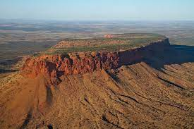
Mount Conner, also known as Atila, Artilla, or Fool-uru, is a mountain located in the southwest corner of the Northern Territory of Australia, 75 kilometres southeast of Lake Amadeus, in the locality of Petermann. It lies within the Curtin Springs cattle station in Pitjantjatjara country, close to the site of the Kungkarangkalpa (Seven Sisters) Dreaming. Its height reaches 859 metres above sea level and 300 metres above ground level.
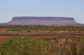
The sides of Mount Conner are blanketed by scree (talus) and its top is blanketed by colluvium. The base of Mount Conner is surrounded by alluvium. The summit of Mount Conner, along with the summits of low domes in the Kata Tjuta complex and summit levels of Uluru, is an erosional remnant of a Cretaceous geomorphic surface. It is considered to be a classic example of an inselberg created by erosion of surrounding strata.

Mount Conner, Aboriginal Artilla, most easterly of central Australia’s giant tors, or monoliths, which include Uluru/Ayers Rock and the Olga Rocks (Kata Tjuta), southern Northern Territory. Rising above the desert plain southeast of Lake Amadeus, Mount Conner is flat-topped and horseshoe-shaped and reaches to 760 metres above sea level; its lower 150 metres are covered by a talus (scree) slope, while the highest 300 feet (90 metres) are sheer cliffs.

The conglomerate and quartzite formation measures 3 km by 1.2 km, with sandstone and limestone ridges extending for 2.5 km from the base. It was visited in 1873 by William Gosse, a government surveyor, who named it for a South Australian politician, M.L. Conner. The region’s Aborigines, who call the mountain Artilla, believe it to be the home of icemen who create cold weather.
No comments:
Post a Comment