
A mesa is an isolated, flat-topped elevation, ridge or hill, which is bounded from all sides by steep escarpments and stands distinctly above a surrounding plain. Mesas characteristically consist of flat-lying soft sedimentary rocks capped by a more resistant layer or layers of harder rock, e.g. shales overlain by sandstones.
The resistant layer acts as a caprock that forms the flat summit of a mesa. The caprock can consist of either sedimentary rocks such as sandstone and limestone; dissected lava flows; or a deeply eroded duricrust. Unlike plateau, whose usage does not imply horizontal layers of bedrock, e.g. Tibetan Plateau, the term mesa applies exclusively to the landforms built of flat-lying strata. Instead, flat-topped plateaus are specifically known as tablelands.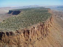
Names, definition and etymology
As noted by Bryan in 1922, mesas "...stand distinctly above the surrounding country, as a table stands above the floor upon which it rests". It is from this appearance the term mesa was adopted from the Spanish word mesa meaning "table".
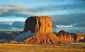
A mesa is similar to, but has a more extensive summit area than, a butte. However, there is no agreed size limit that separates mesas from either buttes or plateaus. For example, the flat-topped mountains, which are known as mesas, in the Cockburn Range of North Western Australia have areas as much as 350 kilometres. In contrast, flat topped hills, which are as small as 0.1 kilometres in area, in the Elbe Sandstone Mountains, Germany, are described as mesas.

Less strictly, a very broad, flat-topped, usually isolated hill or mountain of moderate height bounded on at least one side by a steep cliff or slope and representing an erosion remnant also have been called mesas.

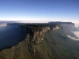
In the English language geomorphic and geologic literature, other terms for mesa have also been used. For example, in the Roraima region of Venezuela, the traditional name, tepui, from the local Pomón language, and the term table mountains have been used to describe local flat-topped mountains. Similar landforms in Australia are known as tablehills, table-top hills, tent hills, or jump ups (jump-ups). The German term Tafelberg has also been used in the English scientific literature in the past.

Formation
Mesas form by weathering and erosion of horizontally layered rocks that have been uplifted by tectonic activity. Variations in the ability of different types of rock to resist weathering and erosion cause the weaker types of rocks to be eroded away, leaving the more resistant types of rocks topographically higher than their surroundings. This process is called differential erosion. The most resistant rock types include sandstone, conglomerate, quartzite, basalt, chert, limestone, lava flows and sills. Lava flows and sills, in particular, are very resistant to weathering and erosion, and often form the flat top, or caprock, of a mesa. The less resistant rock layers are mainly made up of shale, a softer rock that weathers and erodes more easily.
The differences in strength of various rock layers are what give mesas their distinctive shape. Less resistant rocks are eroded away on the surface into valleys, where they collect water drainage from the surrounding area, while the more resistant layers are left standing out. A large area of very resistant rock, such as a sill, may shield the layers below it from erosion while the softer rock surrounding it is eroded into valleys, thus forming a caprock.

Differences in rock type also reflect on the sides of a mesa, as instead of smooth slopes, the sides are broken into a staircase pattern called "cliff-and-bench topography". The more resistant layers form the cliffs, or stair steps, while the less resistant layers form gentle slopes, or benches, between the cliffs. Cliffs retreat and are eventually cut off from the main cliff, or plateau, by basal sapping. When the cliff edge does not retreat uniformly but instead is indented by headward eroding streams, a section can be cut off from the main cliff, forming a mesa.

Basal sapping occurs as water flowing around the rock layers of the mesa erodes the underlying soft shale layers, either as surface runoff from the mesa top or from groundwater moving through permeable overlying layers, which leads to slumping and flowage of the shale. As the underlying shale erodes away, it can no longer support the overlying cliff layers, which collapse and retreat. When the caprock has caved away to the point where only little remains, it is known as a butte.
Examples and locations
Australia
- Cockburn Range, Western Australia
- Mount Conner, Northern Territory
France
- Mont Aiguille, Auvergne-Rhône-Alpes
Germany
- Königstein, Saxony
- Lilienstein, Saxony
- Papststein, Saxony
- Pfaffenstein, Saxony
- Quirl, Saxony
Iraq
- Amadiya, Kurdistan Region
Ireland
- Kings Mountain, County Sligo
- Knocknarea, County Sligo
- Knocknashee, County Sligo
Israel
- Masada, Southern District
- Har Qatum
Italy
- Monte Santo, Sardinia
United Kingdom
England
- Castle Folds, Cumbria
- Cross Fell, Cumbria
- Goldsborough Carr, County Durham
- Ingleborough, North Yorkshire
- Pen-y-ghent, North Yorkshire
- Shacklesborough, County Durham
Scotland
- Healabhal Mhòr, Isle of Skye
United States
Arizona
- Anderson Mesa
- Black Mesa
- Black Mesa
- Black Mesa
- Black Mountain
- Cummings Mesa
- First Mesa
- Horseshoe Mesa
- Indian Mesa
- Second Mesa
California
- Redonda Mesa
Colorado
- Battlement Mesa
- Grand Mesa - largest flat-topped mountain in the world.
- Green Mountain
- Log Hill Mesa
- North Table Mountain
- Raton Mesa
Nevada
- Mormon Mesa
- Pahute Mesa
Oklahoma
- Black Mesa
- Mesa de Maya
Texas
- Floating Mesa
Utah
- Checkerboard Mesa
- Crazy Quilt Mesa
- Hurricane Mesa
- Sams Mesa
- Smith Mesa
- South Caineville Mesa
- Thompson Mesa
- Wildcat Mesa
- Wingate Mesa
Wisconsin
- Grandad Bluff
No comments:
Post a Comment